
Hex Grid Map Systemization
Developing The "Nixy" Grid System!

Welcome to the Glyph and Grok - A weekly blog-letter exploring design, execution, and culture relating to anything played on a tabletop. See the other pieces on Game Design from the Glyph and Grok here.
Introduction
This week’s post is all about a system i’m developing to answer another of my favorite game master rabbit holes, scalable mapping! There are two projects I’m working on that I want to use hex maps that can provide a kind of “analog map zoom”. The typical OSR hex map has a 4-digit number spelling out the hexes on the grid. I’m not sure if there are other systems out there that solve the problem of filling out sub-sections of the hex, but I’m an engineer for my day job who enjoys creating systemic solutions to a problem - even if it is re-inventing the wheel - so I made my own that takes from the military global positions on a square grid, but applied to hexes for the simple reason that I really want to use hexes.
The Thing
First, let’s look at the gird system itself. I want to be able to start at a very high level - at an atlas large area regional level - select one of the hexes and that be broken down into sub-hexes, and those broken down into sub-hexes, and even THOSE broken down into sub-hexes so that I could theoretically be running gameplay on these maps at varying resolutions from 10 or 5 km at the largest and 30 m at the smallest (for example)
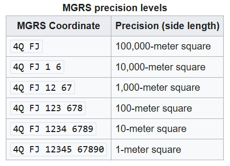
The system is an approximation of the one used by the military for precise scalable location anywhere in the world known as the “military grid reference system” or MGRS. The numbers are always listed with an “easting” and then a “northing”. My layers are not at the same scales as this, and I don’t want to have to worry about as many - I’m trying to create a universal grid system I can apply to some games, not thread someone’s rectum with an ICBM…
I start my system by selecting the “strategic” level designator. Through some mostly arbitrary programmatic bent naming conventions, I’ve decided to call this system the “nixy” hexgrid system because the grid identification system is expressed as such: #N XXX YYY
Get it? #NXY “Nixy” anyways…
I am not even sure if I will need the fourth level of abstraction in all situations, but I feel like 3-4 is the maximum number of these hex grids on 8.5x11 sheets of paper for comfort in play, and you can see what I’m doing via this illustration below:
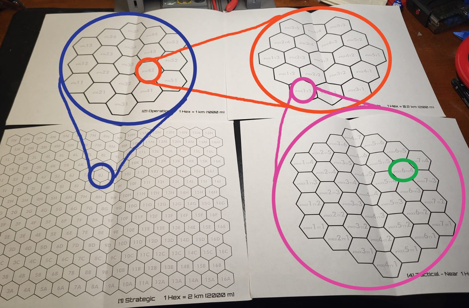
The example above denotes the relationship between the different grids here, they are like a russian doll of hexgrids. Walking down the levels:
8J (Blue) #N - [1] Strategic 1 hex = 5 km
8J 4 2 (Orange) #N X Y - [2] Operational 1 hex = 1 km
8J 41 21 (Pink) #N XX YY - [3] Tactical - Wide 1 hex = 0.2 km
8J 416 214 (Green) #N XXX YYY - [4] Tactical - Near 1 hex = 0.029 km
I spent some time on google map with that smallest value and that 29 meters is about 95 feet and I believe that is a level one could observe a squad mission underway with enough detail. Recall typical movement speed in a ttrpg is 30 ft for 6 seconds. I am not convinced it would work as a scale for playing out tactical combat, but I am convinced it would work as a “monitoring” scale just above where it would be comfortable to execute combat from. I’m looking to use this system for mapping and abstracting gameplay not tactical combat use.
Hopefully that example makes it clear the interaction between the grids and how these universal designations can be used with these grids in their specific orientations to create a collapsible map that can be delved in as deeply or as shallowly as one wants!


Paid Subscribers! - Check the end of this post for download links of hi-res and editable file versions of these items. These are development files and may get edited.
Finally
There are two game projects I plan to use this for. First, is the Catastros regional map I’ve been working on for some time - I think this will be a fun way to explore that large map once I have it completed and seeded - at a level of 10 kM per hex (6.21 miles) at the strategic level. It would be like an analog procedurally generated world - once something is expressed within a specific hex, I can use the grid system to have it bet there next time any player goes to that same place.
The second project is one I am calling “Extraction Command” - the grid was the first step in the process but I think I have enough thought out to say I’m planning to move forward creating a small-ish TTRPG (maybe a one-pager?) that uses this grid system to create rules for a player that acts as the mission command from a ship for squads on planet surface - something like the guy who stands next to the holotable in Helldivers 2. I think it’ll be fun, I’ll release more on that when I have it!
Does the grid system make sense to you? What are your thoughts?
Thank you, dear reader!
Please like, share, and comment your thoughts.
Till next time!

Paid Subscribers - Links Below!
Keep reading with a 7-day free trial
Subscribe to Glyph and Grok to keep reading this post and get 7 days of free access to the full post archives.